Friday 27 December 2013

Convection and explosive thunderstorm development

Convection. It's a term we hear very often in conversations about the weather, especially pertaining to storms. We hear it a lot in weather forecasts, storm warnings and we read about it in weather journals, books and other weather related publications. 

So what is convection? How does it happen? And what role does it play in the development of storms?

The term itself is a general term that has many broad meanings. https://www.vocabulary.com/dictionary/convection

I will be focusing on the weather related side of convection on this post as I am more knowledgeable on that type of convection. From a weather perspective, convection (or more specifically atmospheric convection) refers to the heating of the ground by the sun which in turn heats the air just above it. This then results in a pocket of warm air which rises up into the cooler air above. Upon mixing with the cooler air it condenses and forms clouds. It also release energy in the form of latent heat. The differences in temperature between the warm air and cooler air above leads to atmospheric instability which, if the conditions are just right, will cause the air to expand and lead to the development of cumulus clouds. If there is enough moisture and enough instability is maintained, continued convection will lead to the development of cumulonimbus clouds, the characteristic clouds known to produce thundery weather around the world.


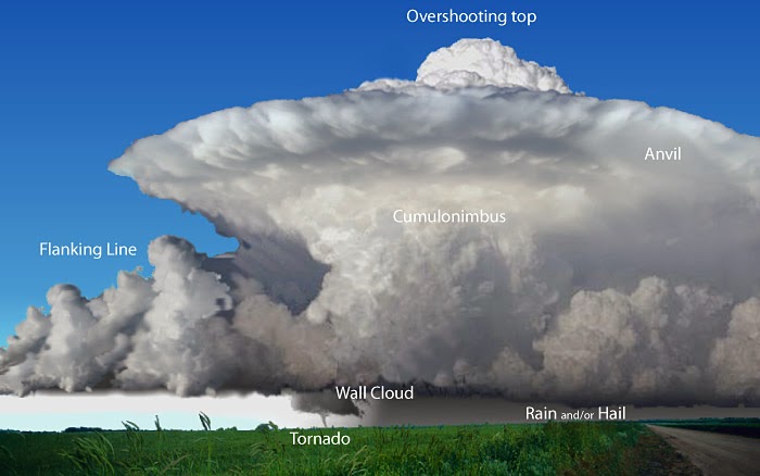
Cumulonimbus cloud with a classic anvil top that spreads out as convection currents that help to form it reach the tropopause, were the unstable troposphere below meets the stable stratosphere above. The tropopause acts like a ceiling, stopping the rising updraft from going further up, causing it to spread out horizontally as convection currents continue to push it up from the ground.


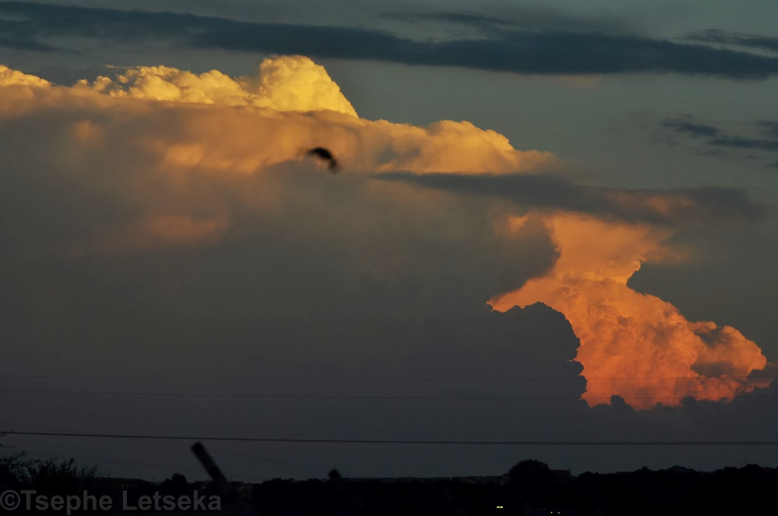
Cumulonimbus cloud with an overshooting top. An overshooting top occurs when the updrafts in a thunderstorm are so strong that they basically punch a hole in the tropopause and continue to rise sometimes up to 2km up into the stratosphere. This is an indication of strong convection currents that can often lead to the development of supercell thunderstorms.
Another commonly used term in weather circles is explosive convection or explosive development. This of course is not really a scientific term but one that is very popular. It refers generally to thunderstorms (not necessarily severe thunderstorms) that develop very quickly, often within a matter of just minutes. Often the vertical movement of the clouds as they rise high into the atmosphere can be visible to the naked eye, giving one an idea of just how strong the convection currents and updrafts are. But the best way to really get an idea of how spectacular an explosively developing thunderstorm is, is by watching it in a time lapse video.


 Thunderstorms, at least here in South Africa anyway, develop explosively when there is high heat and humidity resulting in a high level of instability and strong convection. A strong jet stream also helps. In the Highveld region, explosive thunderstorms also develop when these factors are combined with the presence of a dry line boundary or a cold front that provides the lifting mechanism needed for them to develop.

Meteosat 0-degree Airmass Product, showing convection over southern Africa that typically brings intense (and mercifully brief) storms. Image source: EUMETSAT.
    The satellite image above shows a typical spring and summer weather pattern in South Africa, with intense and explosive thunderstorm activity in the east of the country, while the western part of the country remains largely dry. Taken on the 30 October 2013, it shows intense thunderstorm activity covering the entire Gauteng province, most of Limpopo, Mpumalanga, KwaZulu Natal and small sections of the Northwest Province and the Free State. Such intense and explosive thunderstorm activity is typical for this part of South Africa at this time of the year. Warm moist air from central Africa is drawn south to South Africa where, coupled with the heating of the ground and other factors like the presence of a dry line boundary gives rise to the powerful convection currents that lead to the development of the explosive storms that are typical for this region of the country during the spring and summer.

Tuesday 24 December 2013

Spring and Summer storm clouds


Let me stress first that everything on this blog is based on general knowledge as I am not a meteorologist. I do however make every effort ensure that the information I provide comes from credible sources. If any part of the information I provide is incorrect or inaccurate in any way, I will most certainly appreciate the correct information being provided by those with expert knowledge.

Cumulus Congestus. Largest of the cumulus family of clouds and the final cumulus stage before transition to cumulonimbus
Thunderstorms are in my book the most spectacular weather events on the planet. What other weather system on earth produces such a mix of awesome and sometimes violent weather that thunderstorms produce? In addition to the weather they produce, the clouds that produce them can be just as spectacular.

Near perfect classic cumulonimbus cloud that formed to the far east of Pretoria somewhere over Mpumalanga on 27 October 2013. Although it was never confirmed, it is possible that this storm may have been a supercell


A spectacular cumulonimbus cloud that developed explosively over the east of Johannesburg on 15 December 2013. You can get an idea of how explosive it was in the second of the three time lapse videos below 

From broad cauliflower like cumulus congestus to the massive, towering cumulonimbus clouds that reach high into the stratosphere, nothing beats summer storm clouds when it comes to their ability to inspire awe in those who witness them. In the spring and summer, warm moist air from tropical Africa moves down towards the northern and central parts of South Africa, producing the often spectacular thunderstorms that are a common feature here during that time of the year. That, coupled with the ground heating from the summer sun, creates the convection that's needed for the clouds to develop and eventually grow into the cumulus and cumulonimbus clouds that bring our thunderstorms.

A roll cloud that formed ahead of an approaching storm in Pretoria on the 20 October 2013
One of the things I really love about the clouds that create thunderstorms is the way they develop. From inception to dissipation, there is almost a magical surrealness in the way the thunderheads shoot vertically into the upper atmosphere and the top spreads out to form the characteristic anvil that is the very epitome of the cumulonimbus cloud. One of my favourite ways of capturing a thunderstorm as it develops is through time lapse photography. There's just something about watching the way a cumulus or cumulonimbus cloud just explosively shoot up into the sky and evolve and change shape as it reacts to the environment around it.


The time lapse videos above are three of my favourite because they really capture thunderstorms at their best. I love the third one just for its eerie beauty and the way the clouds at the base of the thunderstorm almost seem to swirl around each other. This storm later produced heavy torrential rain that led to some minor flash flooding in parts of Pretoria.
Shelf cloud approaching Moreleta Park in Pretoria on 8 October 2013
Shelf clouds are among the most spectacular features of spring and summer storms. Their ominous and menacing appearance strike fear into the hearts and minds of those who see them. They are often mistaken for wall clouds and people often fear a tornado might hit when they see them approaching. But fear not. Shelf clouds do not produce tornadoes as they are an indication of an outflow dominant storm, that is a storm that is dominated by downdrafts. Tornadoes and wall clouds mostly form in storms that are inflow dominant, that is where warm air is being sucked up into the usually rain free part of a storm. It is still wise though to take shelter if you see a shelf cloud approaching as it may indicate the presence of very strong winds, heavy rain and often large hail.  
Lightning in Pretoria on the 28 November 2013
 

And last but not least is of course lightning. For me personally this is the most spectacular of all thunderstorm features. Yes, even more than tornadoes. Powerful electrical discharges that light up the evening sky and are so hot (up to 30,000 degrees Celsius, five times hotter than the surface of the sun) that they cause the air to expand rapidly in the form of explosive shock waves we hear as thunder.

Saturday 7 December 2013

Hailstorms

Hail is one of the most destructive natural forces on the planet.These rock hard balls of ice cause billions of Rands worth of damage every year in South Africa alone. And just over a week ago, the residents of Gauteng got to experience first hand just how destructive hail can be. Both Johannesburg and Pretoria were on Thursday the 28 November 2013 pummeled by the most destructive hailstorms to strike both cities in years. In some areas the hailstones were reported to be up to baseball size. In Pretoria, several areas in the townships of Mamelodi and Soshanguve in the north of the city were pummeled by tennis ball to baseball size hail that shattered and smashed windows, punched holes in roofs, dented cars and smashed their windscreens. In Johannesburg, parts of the East and West Rands were also hit by massive hailstorms, causing a great deal of damage. In addition to the hail, damage was also caused by strong winds as well as some localised flooding. But it was the hailstorms that were the main topic of conversation that day.

The leading edge of one of the supercell thunderstorms that pummeled Gauteng with massive hail on the 28 November 2013 passing over Moreleta Park in Pretoria
 So what is a hailstorm, and how does it form? In simple terms, a hailstorm is a storm that is characterised by hail. Now obviously that is not a good answer, and not a good question either. The appropriate question would be, what is hail? Well, hail is a form of precipitation charaterised by often large and very hard clumps of ice that form within the updraft of a thunderstorm. At first glance, we may tend to think that hailstones are made up of a single solid ball of ice. That is not the case. Instead of a single solid ball of ice, hailstones are made up of several layers of ice forming on top of each other as it is carried up and down in the downdrafts and updrafts of thunderstorms. How big the hail gets is largely dependent on how strong the updrafts in the thunderstorms are.   

Hailstones cover the ground in Mamelodi in the north of Pretoria following the hailstorms on the 28 November 2013. Courtesy of Victor Mbinga/iWitness


The two videos below were shot in Pretoria and can be viewed on the following links http://www.youtube.com/watch?v=hIxHRS4T3D0 and http://www.youtube.com/watch?v=7jKnks4i4es respectively. Neither are my own videos, but I included them just to illustrate how ferocious the hailstorms of the 28 November 2013 were. 


The diagram below is a clear but simple illustration of how hail forms. As most of us are already aware, a thunderstorm is composed of an updraft and a downdraft. An updraft is a pocket of warm air which, being lighter, rises up into a thunderstorm, while a downdraft is colder and therefore heavier air falling down to the ground. The interaction between these two different components of thunderstorms lies at the heart of hail formation. As raindrops are sucked up into the storm by the powerful updrafts, they reach the freezing level where they, well....., freeze. The updrafts within the storm prevents them from falling to the ground until they reach a size and weight that makes them too heavy to stay aloft. As they are circulated up and down within the updrafts and downdrafts of the storm, they build up layer upon layer of ice until such a time that they get too heavy to be held up in the clouds, at which point they fall to the ground. How big they get is of course determined by how many cycles they go through in the storm clouds before they eventually fall to the ground. More cycles, more layers, bigger hailstones. The number of cycles is in itself determined by how strong the updrafts within the storm are. And generally, the strongest updrafts tend to develop in the strongest storms. That is why supercell thunderstorms tend to produce the biggest hailstones.  

A diagram of how hail forms in a thunderstorm. Courtesy of http://www.nc-climate.ncsu.edu/edu/k12/.SevereWeather
 The photograph below shows exactly why hail is so destructive. Aside from the jagged edges on the outer perimeter of the hail, the layers that make up hailstones are clearly visible. This particular hailstone, which appears to be at least baseball size, certainly went through quite a number of cycles before it fell to the ground, which means it most likely formed in a very powerful storm indeed.

A large hailstone cut in half to show the different layers it is made up of. http://www.nc-climate.ncsu.edu/edu/k12/.SevereWeather
 Although they don't quite match the hailstone in the above image, the hailstones in the image below fell in Krugersdorp (a well known hail hotspot) in the west of Johannesburg. They appear to be about golf ball size, which still makes them very dangerous. Hail this size is capable of denting cars and smashing windows.

Golf ball size hail that fell in Krugersdorp, west of Johannesburg on the 28 November 2013. Courtesy of Gavin Carter/iWitness

Due to its location and climatic conditions, South Africa is by no means immune to hailstorms. In fact, as the storms of the 28 November 2013 demonstrated, hail is a very common feature of our weather during the spring and summer months. Most hailstorms are concentrated in the summer rainfall belt of the country. Which is not surprising since that is where most of the country's thunderstorm activity is concentrated. In South Africa though, as the map below indicates, hail frequency seems to be associated more with altitude, with the high lying regions of the Drakensberg mountains in Kwazulu-Natal, the Free State, the Eastern Cape and practically the whole of Lesotho showing the highest frequency of hail occurrence. http://planet.uwc.ac.za/NISL/Invasives/Assignments/GARP/atlas/atlas_252t.htm 

Hail day frequency map of South Africa (School of Bioresourses Engineering and Envonmental Hydrology University of Natal Pietermaritzburg South Africa)
Hail producing storms are also known to produce some spectacular cloud formations. These can take many forms, such as mammatus clouds like the ones in the photo below. These were at the back end of the storm that pummeled Pretoria on the 28 November. They were quite beautiful to watch. An example of how beautiful these storms can be while being so destructive at the same time.


Mammatus clouds at the tail end of a supercell thunderstorm in Pretoria on the 28 November 2013

Saturday 16 November 2013

Lightning photography

Lightning is one of the most powerful and most spectacular forces of nature. It is also one of the most common and therefore one of the most dangerous as well. Strange as it sounds, these are the reasons I have developed such a love for it. Its beauty and power have kept me enthralled since I was a little boy, although at that time it was more fear than fascination. My true fascination with it started when I was high school when I eventually overcame my fear. Since then, I always make sure that I am able to watch every storm that passes by.

Lightning during a storm in Pretoria on 12 November 2013
 I've always been fascinated by lightning photography, but in the past it's never really occurred to me to try it because I always thought it is so complicated and that you need fancy expensive equipment to do it. That was until I got my first digital camera. It was a simple Canon 4 megapixel point and shot camera. I had my doubts about it but then I shot my first lightning pic with it in November 2006 and I was hooked.

My first lightning photo, shot in Rietvalleriand in Pretoria in November 2006.
Here's the thing about lightning photography. If you have the right equipment, that is a good camera, with a fully charged battery and enough space in you memory card (believe me you'll need the space. You'll shoot lots of pics before you get that money shot), a tripod and a remote trigger, then you're all set to shoot some lightning. Those are the basics that you need for good lightning photography. Any good digital camera though will do, as long as it has settings that allow for long exposure shots. I shot the photo below with an AgfaPhoto Compact 100 point and shoot digital camera on the 14 November 2013. I didn't use a tripod or remote trigger. I rested the camera lens against the window, using the burglar proof bars to keep it steady. Of course as you can see, my hands weren't quite steady enough in this case as you can see that there was quite a bit of camera shake, which is noticeable with the lights in the distance. But the lightning itself came out perfectly.  That is why a tripod is very important.

Lightning during an intense storm in Pretoria on the 14 November 2013
People often wonder how it is possible to photograph something that is so fast and unpredictable like lightning. I used to wonder the same thing before I started doing it myself. I always thought lightning photography was a complicated thing that ordinary folk like myself couldn't do. I was quite excited to discover to the contrary that that was not the case. 

So the question at hand is how do you photograph lightning? 

Lightning photography is not actually not as hard as many people think. Of course that is not to say it is easy either. The point is it is not quite as complicated as many of you think it is. An important thing about lightning photography is that you need plan for it. Yes, I know, how do you plan for something you can't predict? That's the question I'm sure people always ask. Well here's the thing, a thunderstorm is a large system, covering a relatively large area. During it's lifespan, which can be anywhere from 30 minutes to several hours, it will produce anywhere up to several hundred lightning strikes. If you are in the right location, there is always a chance that you can get at least one or two very shots during the course of the storm. The most important attribute that every lightning photographer needs is patience. The reality is you're not going to get the perfect shot immediately when you start taking pictures, although there are very rare exceptions when it does happen. Most likely, you'll go through several dozen bad and dull shots before you get that perfect one. That's just the nature of lightning photography. If you're generally not a patient person, then lightning photography is just not for you.

There are a number of sites that give tips on lightning photography which I could include here, but that would fill up the entire post and I don't want that. So I have attached these two links to the two sites I felt give the best tips on how to get the best lightning shot you can get.

Lightning strike in Pretoria on the 20 October 2013
Lightning is not only a joy to photograph but it is also such a wonder to watch. Watching such a powerful force of nature streaking across the sky and then striking the ground is alluring and mesmerising as it is frightening. Perhaps that is why lightning photographers like myself feel such a sense of accomplishment and gratification at capturing such a powerful force of nature on camera. Getting the perfect shot after going through 20 or 30 and sometime even 50 to 100 dull ones is probably the happiest moment of any lightning photographer. It is certainly always a happy moment for me.


Thursday 7 November 2013

The wonder of watching distant storms

 Here is something I discovered towards the end of the last storm season. Sometimes the best storms to watch are not necessarily those that are directly overhead or approaching your location. Not at all. Sometimes the best storms to watch are those that are at a distance, too far away to have any effect on your location. 

One particular day always comes to mind. That day was Saturday the 9 March 2013. On this day, there were no storms in Pretoria itself. In fact it was a clear and sunny day over the city for pretty much whole day, with no rain at all. 

The early stages of what was to become one of the best storm watching days of my life
It all started just before 16:30 early that evening when a storm developed to the far east of Pretoria. It developed very quickly into the explosive billowing cumulonimbus cloud in the above image. But even this was still early days. The grand finale of the day was still to come. But I will come to that part a bit later.

Another line of clouds began developing to the NE and also grew into a mass of cumulonimbus that heralded something big about to happen.
  

The two above links are of the two storm systems a bit later in their development. They also include a third separate storm that developed much later but would also develop it's own amazing characteristic. The day would eventually end with one of the most spectacular arrangements of storms I've ever seen. Three storms, one to the south, another to the east and the other slightly to the north. Pretoria was almost basically surrounded on three sides by storms (although they were some distance outside the city, with the one to the east confirmed to be not far from the town of Ermelo in Mpumalanga). http://www.stormchasing.co.za/forums/weather-photographs/8636-pretoria-surrounded-by-storms-9-march-2013
 But what particularly made this set up so exciting was the fact that one of the storms was a possible supercell thunderstorm.

The mammatus storm to the east
The above storm, which I call the mammatus storm, developed from the billowing cumulonimbus formation in the top image. I shot the above photo about two hours after the top one. By then, it had developed a spectacular mammatus formation under it's anvil, which was a beauty to watch. The photo does not really do it much justice as I shot it with my camera phone fully zoomed in. That mammatus was truly breathtaking, even from that distance. I can only imagine what it must have been like for those directly underneath it.

The anvil storm to the south
I think it is quite clear why I call the one above the anvil storm. Just look at how stunning that anvil is. This didn't look like it was a particularly big storm but man that anvil was absolutely gorgeous and such a joy to watch. This began developing  bit later to the south about an hour after the other two storm systems had began developing. It seemed to be the least organised of the storms and looked mostly wispy at the beginning of it's development. The photo below is the anvil storm about 40 minutes before the above photo. At this point I was still largely focused on the other two storms systems which at this point were at a very interesting point in their development. It's just as well that it really began to take shape just as the sun was setting and I was treated to the beautiful sight in the above image.

The anvil storm in the early stages of it's development.

The possible supercell storm to the north
And saving the best for last. The storm above was the giant of the three. This was clearly the biggest of the three storms. It was imbedded within a line of clouds that formed in the north and northeast and only took its later form about 2 hours later.

The possible supercell about 2 hours earlier. It quite amazing to imagine that a few hours later this became the storm in the image above it.
I watched it develop and separate from the rest of the cloud and become a storm on its own. And boy did it. While I am aware that it is very difficult to tell whether a storm is a supercell simply from observing with the naked eye, this storm did seem to display all the hallmarks of a supercell thunderstorm. From the large overshooting top, to the the anvil that spread far ahead of the main updraft area, to the cumulus clouds along the side of the main cumulonimbus structure, an indication of a flanking line, a typical characteristic of a supercell thunderstorm. All these factors indicated that this storm could be a supercell.

Either way, watching storms at a distance is such a joy. Seeing the clouds develop and grow from little puffy cumulus clouds to towering, billowing cumulonimbus clouds in a matter of a few hours is an experience that is difficult to describe in words. And the neatest part? You don't get wet and the chances of being struck by lightning are almost zero. It's therapeutic too, serene almost.

Thursday 31 October 2013

Supercell thunderstorms

Looks like Saturday is always an interesting day when it comes to the weather. The weather was quite dramatic on the 26 October 2013 (a saturday), with several storms possibly going supercellular. I managed to observe two of them from the complex where I live in Moreleta park. They were absolutely beautiful. I managed to shoot one in time lapse and it was incredible watching it change form and shape and seeing the anvil spread in the video. Unfortunately I never did manage get confirmation on whether the storms were indeed supercells. However, supercell or not, these storms were a wonder to watch. Definitely among the most beautiful cumulonimbus formations I've ever seen.

The backside of one of the possible supercells from Saturday 26 October 2013

So, another question. What is a supercell thunderstorm? What sets it apart from other types of thunderstorms? And more importantly, how common are supercell thunderstorms in South Africa?

Well first, here's my take on it. A supercell is basically nature's version of what separates the men from the boys. The supercell of course being the man and the other thunderstorm types being the boys.

Alright then, enough with my own definition of a supercell. Let's get to the serious part. A supercell is a intense long lived thunderstorm with a single rotating updraft called a mesocyclone. Supercells are also sometimes called rotating thunderstorms, for obvious reasons. They are also the rarest and potentially the most destructive type of thunderstorms. 

The beautiful anvil at the front the storm
What sets supercells apart from other thunderstorm types is their rotating updraft, or mesocylone. In addition to their severity and intensity, it is also their duration that sets them apart from other storms. While the mature stage of most other storms last anywhere from 20 to 40 minutes, supercell thunderstorms can last for several hours. It is partly this long duration that makes them so destructive. They also tend to produce the strongest winds, the biggest hail and the strongest tornadoes. Supercells occur in many parts of the world. The general wisdom is that they can occur anywhere where thunderstorms occur regularly, although it is not always that straight forward.

So where do supercells most commonly occur?

A 3D image of a supercell showing all it known characteristics. (Courtesy of http://www.srh.noaa.gov/bmx/?n=supercell)

Supercell thunderstorms are most common in the central plains of the United States. Not surprising since that's where tornadoes most commonly occur. But they can occur in other parts of the country and the world. Other parts of the world where supercells are regularly observed include Canada, Australia, South Africa, Argentina, Brazil, China, Russia and large parts of Europe. These places all have one thing in common. With largely the exception of Brazil, they're all located in the mid latitudes.

The storm in the previous two images in full view.
So how often do supercells occur in South Africa? 

Unfortunately there isn't a lot of information on supercell thunderstorms in South Africa, but it is known that they are quite common.


They most commonly occur in the provinces of Kwazulu-Natal, Gauteng and the Free State, although they can occur in the other provinces as well. And like their counterparts in the central plains of the US, they can produce a whole variety of severe weather ranging from large hail, strong winds, heavy rain and tornadoes.

One of the best supercell photos ever shot. A classic mothership supercell over Texas in 29 May 2001 (Courtesy of Carsten Peter)
Notable supercells that have occurred in South Africa include the supercells that produced the two tornadoes that devastated the township of Duduza in the east of Johannesburg and in the town of Ficksburg in the Freestate on the 3 October 2011. What was interesting about these tornadoes is that they occurred at almost the same time on the same day, which is very rare indeed.  

Another possible supercell thunderstorm outside Pretoria on the 26 October 2013

http://www.youtube.com/watch?v=rdD7yn7mCTg

Click on the link above if you would like see to a time lapse video of the storm in the above image.

Monday 21 October 2013

Squall Line: 19 October 2013

 Saturday the 19 October 2013 was another good day for storm spotting in Pretoria. Like most days that eventually end with good storms, it started out warm to hot with a bit of a stiff breeze, followed by a build up of clouds from the SW and SSW. I first spotted the beginnings of the storm just after getting out of the shopping mall near where I live. I was greeted by the feature in the picture below that appeared to be a roll cloud. It certainly didn't look like a shelf cloud because it was separate from the main storm cloud (shelf clouds are usually attached to the parent storm) but moving in the same direction and at the same rate of speed. It was pretty clear that this was going to be a dramatic storm.

The roll cloud as it approached ahead of the storm from the west
And this dramatic feature (the image below) only served to confirm that this was no ordinary storm indeed. Wall cloud, scud or some sort of a shelf cloud, I guess I'll never know. All I can do at this point is just speculate as to what is was. But whatever it was, this storm was definitely shaping up to be a very exciting one. This wall cloud like feature though still continues to boggle me. What was it? Was it a wall cloud? Was it a shelf cloud? Was it scud? That's a question I'll always ask myself.

Was it a wall cloud? Was it a shelf cloud? Was it scud?
What I did find out though is that this storm was in fact part of squall line that moved over the north of Gauteng that evening. I always get excited whenever I hear that a squall line is on the way or is passing over because squall lines always seem to produce very exciting weather.

Beautiful storm clouds behind the roll cloud as it passes overhead.
So what is a squall line?

A squall line is basically a line of thunderstorms that have a common lifting mechanism. These can take on a number of different forms, called bands. They generally develop ahead of or parallel to a cold front or dry line boundary.

A squall line in the central United States on 5 June 2008 (Courtesy of National Weather Service)


The above squall line is a classic example of squall lines that occur in the US during the spring and summer months and how large they can get. This particular squall line, which occurred on 5 June 2008, stretched from southern Minnesota in the north to Texas in the south. Of course, squall lines don't always get that big. Some squall lines can be a few tens of kilometres long to up to a 1000km long, like the one in the above image.

A squall line viewed from the space shuttle over Florida
 Squall lines are known to almost always produce some form of severe weather. They often produce strong gusty winds, as a result of the strong gust fronts they produce as they move along either a cold front or dry line boundary. They also produce heavy rain and moderate size hail. They rarely produce tornadoes, although tornadoes can form if supercells are imbedded within the squall line.

Shelf cloud associated with a squall line moving over the Belgian countryside (Courtesy of Erwin Klein)
Squall lines are common in South Africa during the spring and summer months, especially in the Highveld. One of the most spectacular squall lines ever photographed in the country moved over Pretoria on 23 October 2012. It was a classic squall line storm featuring the typical long broad shelf cloud that stretched from the Pretoria CBD all the way down to the suburbs of Pretoria East and probably further than that, as well as the strong gusty winds that are typically associated with squall lines. It was an absolutely spectacular sight. 

The only photo I managed to get of the Pretoria squall line on the 23 October 2012
  If you would like to read more about this amazing squall line, you can go to http://www.stormchasing.co.za/forums/weather-photographs/7583-storm-over-centurion-pretoria-23-october-2012


Friday 18 October 2013

Wall cloud or scud?

While driving back to work from a lunch break at home one afternoon on the 30 October 2012, I noticed this rather unusual feature in the distance during a storm that was hovering over the Waterkloof Air Force base in Centurion. Being the curious weather observer that I am, I immediately pulled over to the side of the road to observe the storm in more detail and of course took out my camera to take pictures.
 
The feature that caught my attention in the centre of the picture. Was it a wall cloud, or was it just scud clouds?
 Looking at it, and having seen pictures in books and storms in documentaries on tv, I immediately got very excited at the possibility that I may be witnessing the formation of a wall cloud. I was a little anxious too as it was hovering over a densely populated area and should anything have happened, it would have been potentially devastating indeed.

I stood by the side of the road for about 20 minutes watching it as it hovered almost in one place maintaining that form almost the entire time I was watching it. Unfortunately I believe due to the distance it was from me, I couldn't tell whether it was rotating or not and admittedly even from that distance I could see that it didn't seem to have a very solid structure, as wall clouds usually do. My confusion was further exasperated when I posted the pictures on several weather sites hoping to get some insight into what this feature was. Some agreed that it was indeed a wall cloud, while others dismissed it as just scud clouds that just happen to look like a wall cloud. 

The feature looking even less organised as it continues to hover over Waterkloof Air Force Base.
 The word scud is actually an acronym for "scattered cumulus under deck" and refers to low hanging, detached clouds that are usually found in the outflow of a thunderstorm. They're usually very fast moving and irregular in their movements. Because they swirl and move about the base of thunderstorms, scud clouds are very often mistaken for wall clouds and sometimes even funnels and tornadoes. So how do you spot the difference between a scud cloud and a tornado or wall cloud. http://en.wikipedia.org/wiki/Scud_%28cloud%29.  

Normally one way to tell if you're looking at scud clouds or wall clouds or tornadoes is to look for any visible signs of rotation. Because scud clouds are detached from the thunderstorm base, they do not rotate and although their swirling motion may appear to be rotation, it is irregular and does not follow a constant pattern of movement in any one particular direction. 

Very tornado like scud clouds in Denver, Colorado in 1999. (Courtesy of Christine White)
 The photo above is a perfect example of why it is so easy to mistake scud clouds for tornadoes or wall clouds. As frightening and ominous as these clouds look, they were actually scud clouds that formed as a result of outflow from a gust front as it moved over Denver. There was no rotation or violent movement of any kind and no damage was reported in the area it moved over. For more information of this feature visit http://www.stormeyes.org/tornado/faq/notahose.htm.
Scud clouds that resemble a wall cloud below the the base of a thunderstorm (Courtesy of Jim South)

Tornado like scud in the American Midwest. (Courtesy of Bernard Hulshof)
I myself have been duped by Mother Nature on several occasions having witnessed swirling clouds that appeared very close to the ground and appeared to be in some way rotating and I've thought I might be witnessing the birth of a tornado. Only to find that it was nothing more than some harmless scud clouds. Although scud clouds themselves pose no threat to people or structures on the ground, they are however a sign that severe weather is on the way as they indicate the presence of low level moisture which is a key ingredient in the development of strong thunderstorms. http://valleywx.com/2012/07/27/scud-cloud-picture-from-woodville/

How it looked in the distance in relation to the rest of the storm

Sunday 13 October 2013

Another big Highveld thunderstorm lashes Pretoria: 10 October 2013

Wow, another stormy day on the Highveld. I have to admit though, the severity of this storm was totally unexpected. At first glance it didn't seem like it was going be such a big storm. Even with the mammatus at the beginning I didn't think it would be as bad as it got. After all, the presence of mammatus isn't always an indication of severe weather. But it seems this time it was. In a way, this storm was actually worse than Monday's storm, despite that storm's fearsome appearance.
A spectacular display of mammatus ahead of the storm over Moreleta Park in Pretoria
After the passage of the mammatus, it became quite clear that this wasn't going to be just an ordinary thunderstorm that would pass with just a bit of rain and some lightning and thunder as I originally thought. Almost immediately the wind picked up, a lot and with it, the dust really started to kick up. The clouds, as in the image below, really took on a menacing appearance that said this was going to be one really bad storm. And boy what a really bad storm it turned out to be.http://www.youtube.com/watch?v=cgkpza9Kqew . This video by Danie Bester shows just how bad the storm got. It was shot in the Silver Oaks area of Pretoria East along the Hans Strydom (Solomon Mahlangu) Drive. After the dust had gone, it rained for the next hour or so. It is interesting to note that much of the Johannesburg area got very little or no rain at all that day, while in Pretoria it rained for in some cases more than hour.

These clouds were swirling and twisting very turbulently, which explains the windy conditions that came this storm
 I would also seem that mammatus was the common feature that constantly kept showing up on this day. Mammatus was also observed in parts of Johannesburg as the storm passed over the city. So here is another question. What is mammatus and how does it form? http://ww2010.atmos.uiuc.edu/%28Gh%29/guides/mtr/cld/cldtyp/oth/mm.rxml. Mammatus are pouch-like cloud structures that most commonly form underneath the anvils of thunderstorms (not necessarily always severe thunderstorms). They can form both at the front and rear of the thunderstorms. The term mammatus is derived from the Latin word mama which literally means breasts.

Mammatus over Fort Worth, Texas on May 20 2013 (Courtesy of Sundog Art Photography)
This is regarded as hands down one of the best mammatus photographs of all time. It was shot by John C. Olsen in Hastings, Nebraska in 2004. (Courtesy of John C. Olsen)
There are a number of theories as to how mammatus forms. Mammatus is in fact one of the few cloud types that form when air sinks instead of when it rises, as is the case with most cloud types.http://www.weather.com/blog/weather/8_9259.html, http://eo.ucar.edu/webweather/cloudpic9.html. These two links provide some brief but valuable information into how mammatus clouds form and why they are such a fascination cloud type. Unlike tornadoes, mammatus can occur anywhere where thunderstorms occur, although it does tend to form more in places that have conditions that frequently favour the development of severe thunderstorms, like America's Tornado Alley and the Highveld region of South Africa.

While mammatus may not always indicate severe weather, it turbulent and ominous appearance does indicate huge amounts of turbulence in the atmosphere. For this reason, pilots are strongly discouraged to fly when mammatus is visible in the clouds, even if they are not cumulonimbus clouds.

Dark ominous clouds moving over Moreleta Park in Pretoria on 10 October 2013. Notice the dust in the distance, indicating the strong outflow that brought the strong winds that caused chaos throughout the city.
Mammatus clouds are beautiful to watch and they have a certain allure about them, especially when combined with other beautiful weather features like sunsets, as the image below shows. I shot this picture after the storm on Thursday had passed. I was quite impressed by the beautiful colours of the sunset below and contrast of the dark ominous mammatus above it. It was an amazing juxtaposition of two opposing forces of nature that I just had to capture.
 
Sunset in Moreleta Park following the 10 October 2013 storm with a spectacular mammatus display just above