Saturday 16 November 2013

Lightning photography

Lightning is one of the most powerful and most spectacular forces of nature. It is also one of the most common and therefore one of the most dangerous as well. Strange as it sounds, these are the reasons I have developed such a love for it. Its beauty and power have kept me enthralled since I was a little boy, although at that time it was more fear than fascination. My true fascination with it started when I was high school when I eventually overcame my fear. Since then, I always make sure that I am able to watch every storm that passes by.

Lightning during a storm in Pretoria on 12 November 2013
 I've always been fascinated by lightning photography, but in the past it's never really occurred to me to try it because I always thought it is so complicated and that you need fancy expensive equipment to do it. That was until I got my first digital camera. It was a simple Canon 4 megapixel point and shot camera. I had my doubts about it but then I shot my first lightning pic with it in November 2006 and I was hooked.

My first lightning photo, shot in Rietvalleriand in Pretoria in November 2006.
Here's the thing about lightning photography. If you have the right equipment, that is a good camera, with a fully charged battery and enough space in you memory card (believe me you'll need the space. You'll shoot lots of pics before you get that money shot), a tripod and a remote trigger, then you're all set to shoot some lightning. Those are the basics that you need for good lightning photography. Any good digital camera though will do, as long as it has settings that allow for long exposure shots. I shot the photo below with an AgfaPhoto Compact 100 point and shoot digital camera on the 14 November 2013. I didn't use a tripod or remote trigger. I rested the camera lens against the window, using the burglar proof bars to keep it steady. Of course as you can see, my hands weren't quite steady enough in this case as you can see that there was quite a bit of camera shake, which is noticeable with the lights in the distance. But the lightning itself came out perfectly.  That is why a tripod is very important.

Lightning during an intense storm in Pretoria on the 14 November 2013
People often wonder how it is possible to photograph something that is so fast and unpredictable like lightning. I used to wonder the same thing before I started doing it myself. I always thought lightning photography was a complicated thing that ordinary folk like myself couldn't do. I was quite excited to discover to the contrary that that was not the case. 

So the question at hand is how do you photograph lightning? 

Lightning photography is not actually not as hard as many people think. Of course that is not to say it is easy either. The point is it is not quite as complicated as many of you think it is. An important thing about lightning photography is that you need plan for it. Yes, I know, how do you plan for something you can't predict? That's the question I'm sure people always ask. Well here's the thing, a thunderstorm is a large system, covering a relatively large area. During it's lifespan, which can be anywhere from 30 minutes to several hours, it will produce anywhere up to several hundred lightning strikes. If you are in the right location, there is always a chance that you can get at least one or two very shots during the course of the storm. The most important attribute that every lightning photographer needs is patience. The reality is you're not going to get the perfect shot immediately when you start taking pictures, although there are very rare exceptions when it does happen. Most likely, you'll go through several dozen bad and dull shots before you get that perfect one. That's just the nature of lightning photography. If you're generally not a patient person, then lightning photography is just not for you.

There are a number of sites that give tips on lightning photography which I could include here, but that would fill up the entire post and I don't want that. So I have attached these two links to the two sites I felt give the best tips on how to get the best lightning shot you can get.
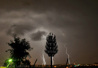
Lightning strike in Pretoria on the 20 October 2013
Lightning is not only a joy to photograph but it is also such a wonder to watch. Watching such a powerful force of nature streaking across the sky and then striking the ground is alluring and mesmerising as it is frightening. Perhaps that is why lightning photographers like myself feel such a sense of accomplishment and gratification at capturing such a powerful force of nature on camera. Getting the perfect shot after going through 20 or 30 and sometime even 50 to 100 dull ones is probably the happiest moment of any lightning photographer. It is certainly always a happy moment for me.


Thursday 7 November 2013

The wonder of watching distant storms

 Here is something I discovered towards the end of the last storm season. Sometimes the best storms to watch are not necessarily those that are directly overhead or approaching your location. Not at all. Sometimes the best storms to watch are those that are at a distance, too far away to have any effect on your location. 

One particular day always comes to mind. That day was Saturday the 9 March 2013. On this day, there were no storms in Pretoria itself. In fact it was a clear and sunny day over the city for pretty much whole day, with no rain at all. 

The early stages of what was to become one of the best storm watching days of my life
It all started just before 16:30 early that evening when a storm developed to the far east of Pretoria. It developed very quickly into the explosive billowing cumulonimbus cloud in the above image. But even this was still early days. The grand finale of the day was still to come. But I will come to that part a bit later.

Another line of clouds began developing to the NE and also grew into a mass of cumulonimbus that heralded something big about to happen.
  

The two above links are of the two storm systems a bit later in their development. They also include a third separate storm that developed much later but would also develop it's own amazing characteristic. The day would eventually end with one of the most spectacular arrangements of storms I've ever seen. Three storms, one to the south, another to the east and the other slightly to the north. Pretoria was almost basically surrounded on three sides by storms (although they were some distance outside the city, with the one to the east confirmed to be not far from the town of Ermelo in Mpumalanga). http://www.stormchasing.co.za/forums/weather-photographs/8636-pretoria-surrounded-by-storms-9-march-2013
 But what particularly made this set up so exciting was the fact that one of the storms was a possible supercell thunderstorm.

The mammatus storm to the east
The above storm, which I call the mammatus storm, developed from the billowing cumulonimbus formation in the top image. I shot the above photo about two hours after the top one. By then, it had developed a spectacular mammatus formation under it's anvil, which was a beauty to watch. The photo does not really do it much justice as I shot it with my camera phone fully zoomed in. That mammatus was truly breathtaking, even from that distance. I can only imagine what it must have been like for those directly underneath it.

The anvil storm to the south
I think it is quite clear why I call the one above the anvil storm. Just look at how stunning that anvil is. This didn't look like it was a particularly big storm but man that anvil was absolutely gorgeous and such a joy to watch. This began developing  bit later to the south about an hour after the other two storm systems had began developing. It seemed to be the least organised of the storms and looked mostly wispy at the beginning of it's development. The photo below is the anvil storm about 40 minutes before the above photo. At this point I was still largely focused on the other two storms systems which at this point were at a very interesting point in their development. It's just as well that it really began to take shape just as the sun was setting and I was treated to the beautiful sight in the above image.

The anvil storm in the early stages of it's development.

The possible supercell storm to the north
And saving the best for last. The storm above was the giant of the three. This was clearly the biggest of the three storms. It was imbedded within a line of clouds that formed in the north and northeast and only took its later form about 2 hours later.

The possible supercell about 2 hours earlier. It quite amazing to imagine that a few hours later this became the storm in the image above it.
I watched it develop and separate from the rest of the cloud and become a storm on its own. And boy did it. While I am aware that it is very difficult to tell whether a storm is a supercell simply from observing with the naked eye, this storm did seem to display all the hallmarks of a supercell thunderstorm. From the large overshooting top, to the the anvil that spread far ahead of the main updraft area, to the cumulus clouds along the side of the main cumulonimbus structure, an indication of a flanking line, a typical characteristic of a supercell thunderstorm. All these factors indicated that this storm could be a supercell.

Either way, watching storms at a distance is such a joy. Seeing the clouds develop and grow from little puffy cumulus clouds to towering, billowing cumulonimbus clouds in a matter of a few hours is an experience that is difficult to describe in words. And the neatest part? You don't get wet and the chances of being struck by lightning are almost zero. It's therapeutic too, serene almost.