Thursday 31 October 2013

Supercell thunderstorms

Looks like Saturday is always an interesting day when it comes to the weather. The weather was quite dramatic on the 26 October 2013 (a saturday), with several storms possibly going supercellular. I managed to observe two of them from the complex where I live in Moreleta park. They were absolutely beautiful. I managed to shoot one in time lapse and it was incredible watching it change form and shape and seeing the anvil spread in the video. Unfortunately I never did manage get confirmation on whether the storms were indeed supercells. However, supercell or not, these storms were a wonder to watch. Definitely among the most beautiful cumulonimbus formations I've ever seen.

The backside of one of the possible supercells from Saturday 26 October 2013

So, another question. What is a supercell thunderstorm? What sets it apart from other types of thunderstorms? And more importantly, how common are supercell thunderstorms in South Africa?

Well first, here's my take on it. A supercell is basically nature's version of what separates the men from the boys. The supercell of course being the man and the other thunderstorm types being the boys.

Alright then, enough with my own definition of a supercell. Let's get to the serious part. A supercell is a intense long lived thunderstorm with a single rotating updraft called a mesocyclone. Supercells are also sometimes called rotating thunderstorms, for obvious reasons. They are also the rarest and potentially the most destructive type of thunderstorms. 

The beautiful anvil at the front the storm
What sets supercells apart from other thunderstorm types is their rotating updraft, or mesocylone. In addition to their severity and intensity, it is also their duration that sets them apart from other storms. While the mature stage of most other storms last anywhere from 20 to 40 minutes, supercell thunderstorms can last for several hours. It is partly this long duration that makes them so destructive. They also tend to produce the strongest winds, the biggest hail and the strongest tornadoes. Supercells occur in many parts of the world. The general wisdom is that they can occur anywhere where thunderstorms occur regularly, although it is not always that straight forward.

So where do supercells most commonly occur?

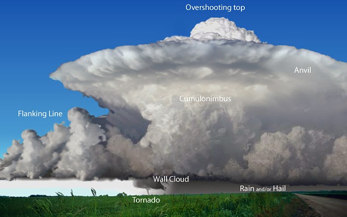
A 3D image of a supercell showing all it known characteristics. (Courtesy of http://www.srh.noaa.gov/bmx/?n=supercell)

Supercell thunderstorms are most common in the central plains of the United States. Not surprising since that's where tornadoes most commonly occur. But they can occur in other parts of the country and the world. Other parts of the world where supercells are regularly observed include Canada, Australia, South Africa, Argentina, Brazil, China, Russia and large parts of Europe. These places all have one thing in common. With largely the exception of Brazil, they're all located in the mid latitudes.

The storm in the previous two images in full view.
So how often do supercells occur in South Africa? 

Unfortunately there isn't a lot of information on supercell thunderstorms in South Africa, but it is known that they are quite common.


They most commonly occur in the provinces of Kwazulu-Natal, Gauteng and the Free State, although they can occur in the other provinces as well. And like their counterparts in the central plains of the US, they can produce a whole variety of severe weather ranging from large hail, strong winds, heavy rain and tornadoes.

One of the best supercell photos ever shot. A classic mothership supercell over Texas in 29 May 2001 (Courtesy of Carsten Peter)
Notable supercells that have occurred in South Africa include the supercells that produced the two tornadoes that devastated the township of Duduza in the east of Johannesburg and in the town of Ficksburg in the Freestate on the 3 October 2011. What was interesting about these tornadoes is that they occurred at almost the same time on the same day, which is very rare indeed.  

Another possible supercell thunderstorm outside Pretoria on the 26 October 2013

http://www.youtube.com/watch?v=rdD7yn7mCTg

Click on the link above if you would like see to a time lapse video of the storm in the above image.

Monday 21 October 2013

Squall Line: 19 October 2013

 Saturday the 19 October 2013 was another good day for storm spotting in Pretoria. Like most days that eventually end with good storms, it started out warm to hot with a bit of a stiff breeze, followed by a build up of clouds from the SW and SSW. I first spotted the beginnings of the storm just after getting out of the shopping mall near where I live. I was greeted by the feature in the picture below that appeared to be a roll cloud. It certainly didn't look like a shelf cloud because it was separate from the main storm cloud (shelf clouds are usually attached to the parent storm) but moving in the same direction and at the same rate of speed. It was pretty clear that this was going to be a dramatic storm.

The roll cloud as it approached ahead of the storm from the west
And this dramatic feature (the image below) only served to confirm that this was no ordinary storm indeed. Wall cloud, scud or some sort of a shelf cloud, I guess I'll never know. All I can do at this point is just speculate as to what is was. But whatever it was, this storm was definitely shaping up to be a very exciting one. This wall cloud like feature though still continues to boggle me. What was it? Was it a wall cloud? Was it a shelf cloud? Was it scud? That's a question I'll always ask myself.

Was it a wall cloud? Was it a shelf cloud? Was it scud?
What I did find out though is that this storm was in fact part of squall line that moved over the north of Gauteng that evening. I always get excited whenever I hear that a squall line is on the way or is passing over because squall lines always seem to produce very exciting weather.

Beautiful storm clouds behind the roll cloud as it passes overhead.
So what is a squall line?

A squall line is basically a line of thunderstorms that have a common lifting mechanism. These can take on a number of different forms, called bands. They generally develop ahead of or parallel to a cold front or dry line boundary.

A squall line in the central United States on 5 June 2008 (Courtesy of National Weather Service)


The above squall line is a classic example of squall lines that occur in the US during the spring and summer months and how large they can get. This particular squall line, which occurred on 5 June 2008, stretched from southern Minnesota in the north to Texas in the south. Of course, squall lines don't always get that big. Some squall lines can be a few tens of kilometres long to up to a 1000km long, like the one in the above image.

A squall line viewed from the space shuttle over Florida
 Squall lines are known to almost always produce some form of severe weather. They often produce strong gusty winds, as a result of the strong gust fronts they produce as they move along either a cold front or dry line boundary. They also produce heavy rain and moderate size hail. They rarely produce tornadoes, although tornadoes can form if supercells are imbedded within the squall line.

Shelf cloud associated with a squall line moving over the Belgian countryside (Courtesy of Erwin Klein)
Squall lines are common in South Africa during the spring and summer months, especially in the Highveld. One of the most spectacular squall lines ever photographed in the country moved over Pretoria on 23 October 2012. It was a classic squall line storm featuring the typical long broad shelf cloud that stretched from the Pretoria CBD all the way down to the suburbs of Pretoria East and probably further than that, as well as the strong gusty winds that are typically associated with squall lines. It was an absolutely spectacular sight. 

The only photo I managed to get of the Pretoria squall line on the 23 October 2012
  If you would like to read more about this amazing squall line, you can go to http://www.stormchasing.co.za/forums/weather-photographs/7583-storm-over-centurion-pretoria-23-october-2012


Friday 18 October 2013

Wall cloud or scud?

While driving back to work from a lunch break at home one afternoon on the 30 October 2012, I noticed this rather unusual feature in the distance during a storm that was hovering over the Waterkloof Air Force base in Centurion. Being the curious weather observer that I am, I immediately pulled over to the side of the road to observe the storm in more detail and of course took out my camera to take pictures.
 
The feature that caught my attention in the centre of the picture. Was it a wall cloud, or was it just scud clouds?
 Looking at it, and having seen pictures in books and storms in documentaries on tv, I immediately got very excited at the possibility that I may be witnessing the formation of a wall cloud. I was a little anxious too as it was hovering over a densely populated area and should anything have happened, it would have been potentially devastating indeed.

I stood by the side of the road for about 20 minutes watching it as it hovered almost in one place maintaining that form almost the entire time I was watching it. Unfortunately I believe due to the distance it was from me, I couldn't tell whether it was rotating or not and admittedly even from that distance I could see that it didn't seem to have a very solid structure, as wall clouds usually do. My confusion was further exasperated when I posted the pictures on several weather sites hoping to get some insight into what this feature was. Some agreed that it was indeed a wall cloud, while others dismissed it as just scud clouds that just happen to look like a wall cloud. 

The feature looking even less organised as it continues to hover over Waterkloof Air Force Base.
 The word scud is actually an acronym for "scattered cumulus under deck" and refers to low hanging, detached clouds that are usually found in the outflow of a thunderstorm. They're usually very fast moving and irregular in their movements. Because they swirl and move about the base of thunderstorms, scud clouds are very often mistaken for wall clouds and sometimes even funnels and tornadoes. So how do you spot the difference between a scud cloud and a tornado or wall cloud. http://en.wikipedia.org/wiki/Scud_%28cloud%29.  

Normally one way to tell if you're looking at scud clouds or wall clouds or tornadoes is to look for any visible signs of rotation. Because scud clouds are detached from the thunderstorm base, they do not rotate and although their swirling motion may appear to be rotation, it is irregular and does not follow a constant pattern of movement in any one particular direction. 

Very tornado like scud clouds in Denver, Colorado in 1999. (Courtesy of Christine White)
 The photo above is a perfect example of why it is so easy to mistake scud clouds for tornadoes or wall clouds. As frightening and ominous as these clouds look, they were actually scud clouds that formed as a result of outflow from a gust front as it moved over Denver. There was no rotation or violent movement of any kind and no damage was reported in the area it moved over. For more information of this feature visit http://www.stormeyes.org/tornado/faq/notahose.htm.
Scud clouds that resemble a wall cloud below the the base of a thunderstorm (Courtesy of Jim South)

Tornado like scud in the American Midwest. (Courtesy of Bernard Hulshof)
I myself have been duped by Mother Nature on several occasions having witnessed swirling clouds that appeared very close to the ground and appeared to be in some way rotating and I've thought I might be witnessing the birth of a tornado. Only to find that it was nothing more than some harmless scud clouds. Although scud clouds themselves pose no threat to people or structures on the ground, they are however a sign that severe weather is on the way as they indicate the presence of low level moisture which is a key ingredient in the development of strong thunderstorms. http://valleywx.com/2012/07/27/scud-cloud-picture-from-woodville/

How it looked in the distance in relation to the rest of the storm

Sunday 13 October 2013

Another big Highveld thunderstorm lashes Pretoria: 10 October 2013

Wow, another stormy day on the Highveld. I have to admit though, the severity of this storm was totally unexpected. At first glance it didn't seem like it was going be such a big storm. Even with the mammatus at the beginning I didn't think it would be as bad as it got. After all, the presence of mammatus isn't always an indication of severe weather. But it seems this time it was. In a way, this storm was actually worse than Monday's storm, despite that storm's fearsome appearance.
A spectacular display of mammatus ahead of the storm over Moreleta Park in Pretoria
After the passage of the mammatus, it became quite clear that this wasn't going to be just an ordinary thunderstorm that would pass with just a bit of rain and some lightning and thunder as I originally thought. Almost immediately the wind picked up, a lot and with it, the dust really started to kick up. The clouds, as in the image below, really took on a menacing appearance that said this was going to be one really bad storm. And boy what a really bad storm it turned out to be.http://www.youtube.com/watch?v=cgkpza9Kqew . This video by Danie Bester shows just how bad the storm got. It was shot in the Silver Oaks area of Pretoria East along the Hans Strydom (Solomon Mahlangu) Drive. After the dust had gone, it rained for the next hour or so. It is interesting to note that much of the Johannesburg area got very little or no rain at all that day, while in Pretoria it rained for in some cases more than hour.

These clouds were swirling and twisting very turbulently, which explains the windy conditions that came this storm
 I would also seem that mammatus was the common feature that constantly kept showing up on this day. Mammatus was also observed in parts of Johannesburg as the storm passed over the city. So here is another question. What is mammatus and how does it form? http://ww2010.atmos.uiuc.edu/%28Gh%29/guides/mtr/cld/cldtyp/oth/mm.rxml. Mammatus are pouch-like cloud structures that most commonly form underneath the anvils of thunderstorms (not necessarily always severe thunderstorms). They can form both at the front and rear of the thunderstorms. The term mammatus is derived from the Latin word mama which literally means breasts.

Mammatus over Fort Worth, Texas on May 20 2013 (Courtesy of Sundog Art Photography)
This is regarded as hands down one of the best mammatus photographs of all time. It was shot by John C. Olsen in Hastings, Nebraska in 2004. (Courtesy of John C. Olsen)
There are a number of theories as to how mammatus forms. Mammatus is in fact one of the few cloud types that form when air sinks instead of when it rises, as is the case with most cloud types.http://www.weather.com/blog/weather/8_9259.html, http://eo.ucar.edu/webweather/cloudpic9.html. These two links provide some brief but valuable information into how mammatus clouds form and why they are such a fascination cloud type. Unlike tornadoes, mammatus can occur anywhere where thunderstorms occur, although it does tend to form more in places that have conditions that frequently favour the development of severe thunderstorms, like America's Tornado Alley and the Highveld region of South Africa.

While mammatus may not always indicate severe weather, it turbulent and ominous appearance does indicate huge amounts of turbulence in the atmosphere. For this reason, pilots are strongly discouraged to fly when mammatus is visible in the clouds, even if they are not cumulonimbus clouds.

Dark ominous clouds moving over Moreleta Park in Pretoria on 10 October 2013. Notice the dust in the distance, indicating the strong outflow that brought the strong winds that caused chaos throughout the city.
Mammatus clouds are beautiful to watch and they have a certain allure about them, especially when combined with other beautiful weather features like sunsets, as the image below shows. I shot this picture after the storm on Thursday had passed. I was quite impressed by the beautiful colours of the sunset below and contrast of the dark ominous mammatus above it. It was an amazing juxtaposition of two opposing forces of nature that I just had to capture.
 
Sunset in Moreleta Park following the 10 October 2013 storm with a spectacular mammatus display just above

Wednesday 9 October 2013

Centurion shelf cloud: 22 November 2012

Today was unfortunately for me and I'm sure for countless other storm lovers across South Africa, another quiet sunny day. Don't get me wrong, I love sunshine, boring as it is. But there has been way too many sunny days in the past few weeks and I've quite frankly had enough of them. In the meantime, I'll post another storm from the past that blew me away. This is from the 22 November 2012.


And wow, what a day that was. It was a hot day on a Thursday and was the day of the Centurion Nikerun at Centurion mall. I saw this shelf cloud forming later that afternoon just after arriving in Centurion and decided to get snapping. The storm itself wasn't very severe in terms of it's overall intensity, but the shelf cloud was quite a beauty to watch. It was nowhere near as dramatic as Monday's shelf cloud, but still beautiful nevertheless.

Shelf cloud over Centurion in Pretoria, South Africa on 22 November 2012
 It took on many forms as it slowly over Centurion, crossing the N14 highway over the hill and the Gautrain viaduct, the long grey structure cutting across the landscape. The thing about it that really caught my attention though was the odd looking lowering to the left of the images. I didn't know what it was but it quite a spectacle to watch. It appeared to be rotating and kept lowering and rising back into the cloud almost like a tornado. It certainly wasn't a tornado though, since shelf clouds don't produce tornadoes. At one point it got down so low it seemed to almost touch the trees in the distance.

It was quite an experience indeed standing there watching this beauty make its way across the Centurion landscape. The lightning was also quite impressive, streaking and dancing across the sky and the several number of Gautrains moving back and forth on the viaduct didn't seem to be much affected by the storm. 

A wide view of the shelf cloud, also showing the size of the storm.

So what exactly is a shelf cloud and how does it form? According to general descriptions, a shelf cloud is a low, horizontal wedge-shaped cloud, usually attached to the base of a severe thunderstorm. To understand How a shelf cloud forms, think of a cold front and how it's formed. Now think of it on a smaller scale, but with the same properties. That's pretty much how shelf clouds form. http://weathersavvy.com/Q-Clouds_ShelfCloud.html

Shelf clouds are part of a family of clouds called arcus clouds, which also includes roll clouds. http://en.wikipedia.org/wiki/Arcus_cloud

Although they usually share the same general shape, as you can see from the three images below, shelf clouds still come in many different forms, sizes and intensity. 
Shelf cloud over the city of Enschede in The Netherlands (Courtesy of John Kerstholt)

Shelf cloud approaching Sydney, Australia (Courtesy of Nick Moir)

Very odd looking, but menacing shelf cloud in Crawfordsville, Iowa (Courtesy of Nick Nolte)
 Shelf clouds are very often mistaken for wall clouds and mesocyclones, and I know, I've made that mistake myself on numerous occasions. They may look similar in appearance by they couldn't be more different. Firstly, they form in different areas of thunderstorms. Shelf clouds form at the front, or leading edge of a thunderstorm and are associated with downdrafts and outflows. Wall clouds on the one hand form at the rear of severe thunderstorms, an area that is usually rain free and where the updrafts occur and are usually associated with inflow. http://vermilionweather.com/wallshelf.php


Tuesday 8 October 2013

Finally, a big storm shows up: 07 October 2013

All I can say about today is just WOW!! After more that two weeks of quiet, sunny weather, Pretoria was finally treated to what I can only describe as a true Highveld thunderstorm. I must admit though, I didn't have much hope of anything happening today. We'd had other days in the past two weeks when thunderstorms were forecast but then nothing happened. I figured today would be another one of those days. Am I glad I was proven wrong.

Shelf cloud approaching

In many ways, it was the calm before the storm. And when the storm finally arrived, boy was it something. The shelf cloud was absolutely spectacular as it rolled over the horizon and approached. The lightning was also a hell of a sight to watch.  


At first I thought the storm was part of a squall tine. But I heard from one of my contacts on Facebook that it was part of something called a QLCS or quasi-linear convective system, http://www.meteor.iastate.edu/~ralliss/qlcsmesovorticies.pdf. Today's weather didn't disappoint. Some areas even got hail, although I wouldn't really look forward that. The satellite and radar images for this weather system were absolutely impressive, showing a line of storms stretching from south eastern Botswana all the way through Swaziland to the nothern KZN coast. This was a huge system indeed.

Satellite and radar map from 07 October 2013, showing the quasi-linear convective system over the north eastern part of South Africa. The capture on this map is 20:00. By now the system  had mostly moved on from Gauteng and was largely affecting Mpumalanga, parts of Limpopo and Swaziland. (Courtesy of Kobus Botha Weather, http://www.weatherphotos.co.za/photos/rain_severe_new.jpg)
It was quite amazing how quickly it moved once it had formed. The time that elapsed from the first photo to the last one was less that 10 minutes. During that time, the shelf cloud kept evolving and taking on different forms and the whole system itself looking really menacing as it inched ever closer. Eventually the lightning eventually begun striking a little too close for comfort and I had to pack up my equipment and head for shelter. Storms can very exciting to watch and document but they're also extremely dangerous and every precaution has to be taken to stay safe when outdoors during a storm. Safety always comes first. I shot these photos from the balcony of the first floor of the local shopping centre just outside the gym and as you can see, it left me dangerously exposed to the storm. Add to that the fact that I had a tripod with a remote trigger connected to the camera and the danger was upped tenfold. As soon as I realised that the lightning was dangerously close, I immediately went into action and took shelter. In fact I should have actually taken shelter the first moment I saw the storm on the horizon, but then that would have meant missing out on all the action, and I couldn't let that happen. However, it is still important to take shelter as soon as you see a storm approaching.   


If you would like to know more about quasi-linear convective systems, you can look up Ron Przybylinski, an American meteorologist who is also a leading expert on QLCS and other associated weather phenomenon. You can find one of his many studies on these often mysterious weather systems at this link: http://www.crh.noaa.gov/lsx/?n=qlcslatest


Monday 7 October 2013

First lightning shot: November 2006

My very first lightning shot. 
This here is my very first photograph of a lightning bolt. I shot it sometime in November 2006 in Elardus Park in Pretoria. I shot a number of other shots that came out terribly. It was very frustrating. At some point I wanted to give up but kept shooting. Eventually I managed to get this amazing shot and when I saw it on the screen of my camera, I couldn't contain my excitement. I didn't even bother waiting around for the rest of the storm. I just went straight to the computer and uploaded it. 

The first lightning shot, no matter how much better subsequent shots are, is always the most sentimental. I keep this one in my special archive where it will hopefully be forever a constant reminder of how far I've come.

When was your first lightning shot and how did it feel to capture this force of nature on camera for the first time?

Sunday 6 October 2013

Midnight storm 12 January 2012

This was one hell of a night I'll never forget. It was just under an hour after midnight and I had only just fallen asleep when I was woken up by a loud rumble of thunder. As I looked out the window I could already see the bolts of lightning streaking across the sky and even though it hadn't gotten that intense at the time, something in me just told me that this is a storm I do not want to miss. Well, boy am I glad I followed my instincts, cause within barely a few minutes of me grabbing my camera this thing just went ballistic. 

This was one of the closest strikes. The thunder clap from
this one was absolutely deafening.
 For the next half hour or so, I had the privilege of witnessing and photographing one of, if not the most intense and most breathtaking lightning storm I've ever experienced. The strikes were almost continuous for nearly the entire duration of the storm and as you can see in the photos, often a little too close for comfort. The thunder was spectacularly deafening, rattling the windows so hard it almost felt like an earth tremor. Fortunately I was indoors the entire time although I'm aware that's not always a guarantee of safety, especially if you're pressing the camera against the window and holding on to steel burglar proof bars. Interestingly, for a storm of this intensity, there was very little to no wind. I found that very strange indeed.    

A lone but very intense strike. 

Pretoria and Johannesburg are located in what's known as the Summer rainfall belt region, an area encompassing basically the entire eastern half of South Africa. One particular region though, in which Pretoria and Johannesburg are located, is especially legendary when it comes to thunderstorms. Known as the Highveld, it's a region located in the inland central region of South Africa and is basically a high altitude plateau encompassing parts of the Northern Cape, Northwest Province, Limpopo, Mpumalanga and pretty much all of Gauteng and the Free State: http://en.wikipedia.org/wiki/Highveld. Thunderstorms like the one covered in this and the previous post are a common feature of the highveld during the spring and summer months. But I must admit though that the one covered in this post was quite insane, even for a Highveld thunderstorm.

Lightning ground flash density map for South Africa (Courtesy of http://www.wattronics.co.za/wp/page/2/ and the CSIR ) 
As you can see in the lightning ground flash density map above, much of the lightning activity in South Africa, which in turn translates to thunderstorm activity is concentrated mostly in the eastern half of the country (the summer rainfall belt). As is evident in the map, the Highveld makes up a significant portion of this area with a high density of lightning ground flashes. Cooler colours indicate a higher density of lightning ground strikes while the warmer colours indicate a lower density of strikes. As you can see, Johannesburg and Pretoria both fall inside the blue area, cementing their reputation as high density lightning strike locations. The areas with the highest density of ground strikes, shaded in black, are in the central Drakensberg region of north eastern Lesotho and southern Kwazulu-Natal and northern Kwazulu-Natal, the south of Swaziland and south easten Mpumalanga. 

Massive double strike. This one just took my breath away. I
couldn't believe how beautiful it was.
I'm sure some or most of us have experienced a storm that was either the most exciting, intense or most terrifying. I would very like you to share your experience of a storm you consider to be any of, or a combination of those three things and tell me what is like for you to go such an event.  

Saturday 5 October 2013

New Year's Eve storm 2011

I've decided to start this blog about severe weather in South Africa as there aren't many of them around. Although this blog will cover severe weather in general, the main theme will be mostly lightning. Let me first start by clarifying that I am not a meteorologist nor am I an expert in severe weather, or any other kind of weather. I'm just a guy who's fascinated by severe weather and the power and beauty that it displays.


Bright lightning flashes over Moreleta Park in Pretoria on 31 December 2011

Anyway, as most of us know, lightning a one of the deadliest natural phenomenon in the world and kills a large number of people every year. South Africa is considered to be a lightning prone country, with a high number of lightning strikes recorded across the country every year. I'm fortunate to live in the part of the country that experiences one of the highest number of lightning strikes. Being located in the Highveld region of South Africa, Gauteng is struck by numberous thunderstorms during the spring and summer period from around October to March every year. Some of these thunderstorms can be very intense and often very severe, bringing heavy rain, lightning, strong winds, sometimes large hail and occasionally even tornadoes.


Lightning however, being the most common of the features of thunderstorms in South Africa is considered to be the big threat when summer storms approach. This article by Morne Gijben highlights just how important lightning research is in South Africa. http://www.sajs.co.za/sites/default/files/publications/pdf/740-8137-1-PB.pdf

Intra-cloud lightning from the  same New Years Eve storm in Pretoria.